Low probabilities – large consequences: Reducing the vulnerability of the Dutch population to floods.
The Context
Justin Gillis recently sub-titled a report on global warming and coastal flooding, in The New York Times (4 Sept 2016), “Scientists’ warnings that the rise of the sea would eventually imperil the United States’ coastline are no longer theoretical.” As he adds, “The inundation of the coast has begun.” He reports that local officials are desperate to find solutions, while climate-denying Republicans in Congress block research and funding on climate change and sea level rise.
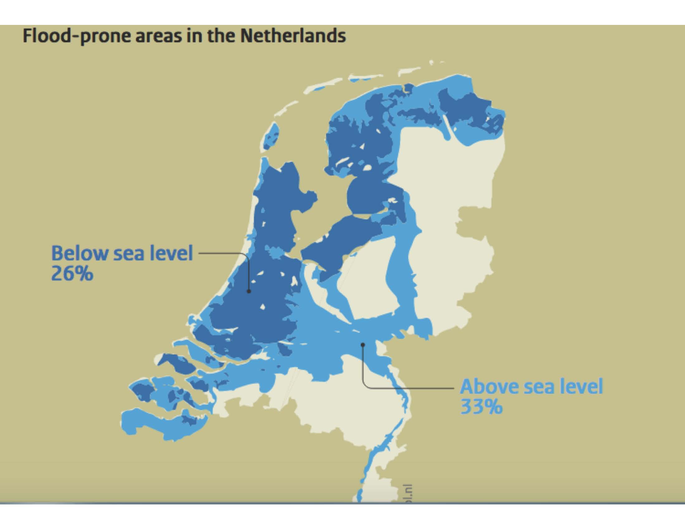
If you are trying to determine how to plan for future rising waters, in rivers and coastal areas, it is always useful to check out what the Dutch are doing. The forward thinking, long-term planning, imaginative approach, and financing by the Dutch grew out of their natural conditions and history. A total of 59% of Dutch surface is subject to flooding, including 26% that lies below sea level. Its history is formed by its geography, and it struck with a vengeance in 1953. A storm tide breached more than 90 dykes in the south-west of the Netherlands, killing 1800 people and causing in excess of €700 million in damages. The Dutch have not forgotten that catastrophe.
They also realize that such a catastrophic breach of dykes now would be much more devastating because the Dutch economy has strengthened, the population has grown, and 70% of that population live in flood-prone areas. By 2030, between 12 and 13 million people will be at risk from flooding, and by 2050 it will be about 14 million, with a breakdown in infrastructure, including transport, energy and communications. Increased climate change will continue to exacerbate the risks.
What the Dutch Are Doing
Following the 1953 catastrophe, the Dutch began an extensive, and expensive, program to reinforce existing dykes and levees. The Netherlands has now adopted a new flood risk policy summarized in a report from PBL, the Netherlands Environmental Assessment Agency: Low probabilities – large consequences: Reducing the vulnerability of the Dutch population to floods. The policy relies both on protecting against the worse flooding; planning by adapting to sustainable spatial organization; and, managing what flooding undoubtedly will occur.
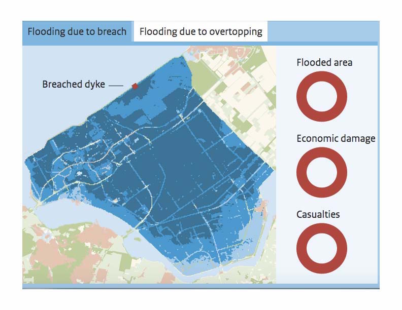
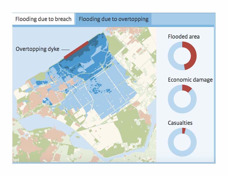
The first priority is to reinforce those levees and dykes that protect the greatest number of potential victims and only maintain those that affect smaller populations. The report acknowledges that “As a result, the probability of breaches will be reduced considerably, and the probability of flooding due to overtopping will increase.”
The breach of a dyke or levee is significantly more dangerous than overlapping as the Dutch learned in 1953, and the people of New Orleans learned from Katrina in 2005. The report includes a clever, interactive graphic that allows readers to see the broader, far more significant effect of a breach and then the more limited impact of the same area with just overtopping of the dyke in Southern Flevoland.
The PBL estimates that the plan will require €1 billion per year for the period 2016-2028, or a total of about €15.2 billion.
Besides hard construction projects, like levees, to protect its people, the Dutch have adopted a policy of “smart evacuation” to reduce the number of casualties. They have learned that evacuating all the inhabitants out of an area at risk is not always necessary, or even safe. If there is evacuation, many jump into their cars and flee. But sometimes they actually flee to more dangerous places and put themselves at greater risk.
The Dutch have determined that many people can find safe haven by staying at home on an upper floor. For those not able to stay at home, or without high floors, the Dutch have determined that public buildings or office buildings in the area can provide safety. However, the report admits that there is much work to be done to ensure that new buildings are designed, sited and built to serve as flood-prone shelters, e.g., building on elevated ground.
Another clever interactive graphic allows you to see how many could stay at home safely in Utrecht in the case of a flooding event.
Conclusion
One of the valuable contributions of the Dutch policy is its directness in language and concept. It acknowledges that what it is doing will protect many but still leave some at risk. They objectively lay out the calculated risks of what they are doing. If only the Irish, and other governments, were capable of such concrete and direct thinking and planning.
Clearly the British government is not there yet. The Conservative-led coalition under David Cameron significantly cut funding for flood protection, but had to restore some of that funding after severe flooding in 2013-2016. Now a recent report estimates that there will be a 20-30% increase in extreme rain storms, and the UK government is allocating £12.5 million for more “temporary defences.” Recall that the Dutch are spending €1 billion per year. Critics find that the UK plan is inadequate in that does not even address surface water flooding, which represents a greater threat in the UK than coastal and river flooding. The plan also ignores any comprehensive, long-term planning for flood risks.
Looks like the UK has adopted the thumb-in-the-dyke solution.
Sources
PBL Netherlands Environmental Assessment Agency, Low probabilities – large consequences: Reducing the vulnerability of the Dutch population to floods. themasites.pbl.nl/flood-risks/
Justin Gillis, “Flooding of Coast, Caused by Global Warming, Has Already Begun: Scientists’ warnings that the rise of the sea would eventually imperil the United States’ coastline are no longer theoretical,” The New York Times (9 Sept 2016). www.nytimes.com/2016/09/04/science/flooding-of-coast-caused-by-global-warming-has-already-begun.html
Damian Carrington, “Flooding: UK government plans for more extreme rainfall,” The Guardian (8 Sept 2016). www.theguardian.com/environment/2016/sep/08/flooding-uk-government-plans-for-more-extreme-rainfall
Originally published at themasites.pbl.nl/flood-risks/ by PBL.
PBL Netherlands Environmental Assessment Agency is the national institute for strategic policy analysis in the fields of the environment, nature and spatial planning. It contributes to improving the quality of political and administrative decision-making by conducting outlook studies, analyses and evaluations in which an integrated approach is considered paramount. Policy relevance is the prime concern in all its studies. It conducts solicited and unsolicited research that is always independent and scientifically sound.
No comments yet, add your own below